Tuesday, 19 July 2011

Marseille

Our journey from Ajaccio was uneventful enough, fortunately as it turned out.  When our ferry docked at Toulon, we queued at the exit.  We were prevented from leaving by the staff who, shortly after, admitted four of the local police to deal with four of our fellow passengers in relation to a “vol”.  There was no information on what was stolen, from whom, how it was discovered or how the perpetrators were apprehended, but we were later pleased to recall that we had locked our cabin from the inside before sleeping peacefully on the calm Mediterranean for the passage to Toulon.

I have never been to Marseille, so all my impressions were formed by the media, in particular, movies.  They always seemed dark, dangerous and ugly, and so my expectations of the city were not high. We decided to spend our last few days of the trip in Marseille for two reasons.  Firstly, neither Dominique nor I had been to France’s second largest city and second, our train to Paris CDG on Tuesday was leaving from Marseille, and so to stay anywhere else would require another change of hotel.

First impressions were positive.  We found a hotel a short walk from the old port, took a walking tour around the area know as Le Panier, or the basket, which was named after a tavern which now no longer exists.  I was surprised to find that, in order to limit hiding places for the members of the resistance, the German troops in 1942 demolished 3,000 homes in this area, which was the site of the old walled town.  Combine this loss with the destruction of churches and royal buildings during the revolution and it is not surprising that the city was known as the ancient city with no signs of age.

Unfortunately, the museum of the ancient town, which is build around the archaeological findings which emerged with the construction of a shopping centre near our hotel, was closed for renovations. However the remains provide a physical link between modern Marseilles and the Greek and Roman ports established in the area.

Further up the hill, the old town is undergoing a slow gentrification, after being mostly abandoned to the immigrant workers recruited for the port and the related industries when the new part of town was built on the other side of the old port in the 19th century.

We were delighted to find a small, new and creative museum devoted to the French national anthem, which of course, was the song of a regiment from Marseille which became the theme of the revolution.


They got a little carried away with the toilet design.


After the first good impressions, there were a few bad impressions which followed.  Urine – it seems that every man in town pisses just about anywhere he wants, and is proud to leave his scent for following alpha males to recognise and try to obliterate with their own piss.  Garbage – it seems that, in spite of a good supply of rubbish bins on the street, it is more acceptable to just throw stuff on the ground.  Sewer smells – around every corner.  I find it hard to understand how a society that can produce the glorious fountains of Versailles, the canal du midi and provide the world with two of the major water supply and treatment companies internationally, cannot seem to manage to get the sewer right at home - but they can’t.

My final bad taste came from one of the most recognisable structures in Marseilles, the Basilica of Norte Dame de la Garde.
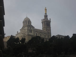
Not subtle
NDLG in on the hill to the South of the city and is one of the basilicas built during the 18th century along with, for example, a similar monstrosity overlooking the otherwise beautiful city of Lyon.  The structure sets out to be imposing with a huge statue of Mary carrying the baby Jesus on top of the church.  The diameter of the arm of the baby is 1.1metres, so you can judge the size of the rest.  The church is horrendously over decorated with gold, sparkles, stained glass and statues richly covered in every spare space in the building, and that is bad enough.  


Some views of the interior NDLG


What is worse it that every spare flat space, including most of the outside walls around the edge of the property, is covered by little marble plaques with messages of thanks to NDLG for some or other miracle.


The official claims of the church, set out carved in marble for all to see, include the protection of Marseille from destruction during the second world war (see above, apparently the protection does not extend to the poor areas), and the eventual liberation of the town. One of the personal messages was a thank you for winning the Tour de France and for assistance with the struggle against drugs in the following months.  I wonder how NDLG chose who to support, why she supported a drug cheat and why she did not support anyone the following year.


These concerns are all trite, but we did visit around 11.45 while the Sunday mass was underway in the Crypt. We noted that there was a café upstairs, and so made our way up for a bracing coffee prior to the walk down the hill.  We found ourselves in a restaurant, with sufficient seats for 50 to 70 people, all reserved.  We watched the congregation wend its way up to the restaurant and take their places, to be served by several young women in what looked like representative dress, if not national dress, from a range of poor, third world countries.  They were polite, respectful and hard working  (the young women, not the congregation)– meeting the needs of the good (catholic) burghers of the parish of NDLG.  A conversation with one of the young women, in perfect French, confirmed my suspicions.  The best and brightest young women of Africa and Asia had devoted their youth to becoming novices of the order of nuns who had their headquarters at NDLG.  Their vocation was to feed the hungry masses, after mass, with the plat du jour.

France, the eldest sister of the church, is sometimes the ugly sister.

Corsica - Ajaccio


We spent two days in Ajaccio before heading out on the ferry to Toulon and beyond. Our main purpose was to view the 14th July celebrations, although we also wanted to have a look around.

Ajaccio is the capital of the south west province of Corsica, and stands at the head of the Gulf d’Ajaccio and on the mouth of the Prunelli River. It has been around in its current incarnation since it was founded in 1492 by the Genoese, but the area has been inhabited since pre-historic times as is clear in the evidence of many monuments around the coast. 

The town is famous for being the birth place of Napoleon Bonaparte and the Bonaparte family has left its mark on the city with statues, roads and squares all bearing the B word as their name.  As is the case across France, this is more due to the work of Napoleon III than anyone else and there is a feeling that NB was not entirely true to his Corsican roots.
 
Paying Homage to the Emperor


The other Bonapartian legacy was left by Napoleon’s uncle, Cardinal Fesch, who – in spite of devoting his life to the church – managed to accumulate more than 16,000 paintings while in Italy on official duties, and in the end bequeathed them to the state of Corsica for the pleasure of its later tourists.

We felt we had Ajaccio covered but we went on a guided tour of the city organised by Office de Tourism, and found a passionate and verbose young man who told us about “Red Gold”. The tour covered the history of the trade in red coral which underpinned the economy  of the city for much of the last four hundred years.  In fact, by the 1700s around 75% of the population of Ajaccio was employed directly by the coral industry.  There were 250 boats collecting coral, and the industry had been operating since Roman times.  In the 16th century, the coral was harvested by divers who broke off coral pieces in relatively shallow water.  However, over time, the resource was depleted and the divers had to dive deeper and deeper.  The result was that divers frequently suffered from the bends and died at a young age.  Only 5% of the population made it to the age of 60, which indicates how dangerous the industry was for its participants.

As the resource was further depleted and left only coral too deep for divers to harvest, the approach to coral collection changed. The innovation of the Croix St Andre – a cross in an x shape on the end of a heavy anchor – allowed collection of coral from the deeper reefs.  The Cross operated by simply dragging along the coral and catching onto the branches, breaking them off and carrying them to the surface.  While the tool was effective at breaking the coral, the capture was less effective and only 30% of the broken coral reached the surface.  What is remarkable is that this methodology continued until its eventual banning in 1996 – a wasteful and unsustainable industry abusing a limited resource, just to make jewelery.

Napoleon helped out the coral industry in his home town by encouraging his wife, the Empress Josephine, to wear a piece of coral jewellery as part of her official jewels – this had the desired fashion impact and improved the profitability if not the sustainability of the Ajaccio coral miners.

Elsewhere in Ajaccio, we visited the French Submarine Hunter the Montcalm which was just back from Afghanistan and Libya (blockading the ports, not chasing ships of the desert).  Unfortunately, we could not decipher the signal flags, even with Google.

The Montcalm with its signal flags-  Vanessa?
We cruised on the harbour at night to watch the fireworks. 


And marvelled at the appropriation of the limited road space by cafés so that they could create outdoor seating to allow patrons to smoke.

It was probably a parking space in a former life


We, however, spent most of our time spotting the impact of years of excessive sun damage on the population of the older women in Corsica. 


A cluster of fine examples on closer inspection
I bought some more block out, I hope I am not too late.

Corsican Music Three

We found a pleasant little restaurant in Ajaccio on Rue du Comte Bacciochi, a wide pedestrian street (meaning only some cars use it) with the restaurant on the footpath, and enough room to stay away from the smokers.  The woman who served us coffee there in the morning promised that there would be music in the evening, and so we decided to sample our third offering of Corsican music, this time with food.  So we returned that evening (14th July) to have dinner before heading down to the fireworks.

When we arrived we encountered the scene in this photo.  Duelling musicians.

Musicians on each side of the road in competing restaruants


Our restaurant was the one on the left, and our entertainment for the night was a guitarist playing jazz / blues loud enough to be heard on the restaurant on the other side of the road.  The restaurateur on the right had hired his own performer in order to attract the crowds to his establishment, but he was around 5 minutes too late. Our guitarist played continuously, not leaving a gap for the opposition to start up and drown him out. Le Patron across the road was more and more agitated as our restaurant was filling with customers and he had only 2 –not counting his children sitting out the front to make it look like there were plenty of customers.  Finally, our performer tired, and took a break, however the entertainer across the road had stopped for dinner and the Le Patron had disappeared. 

Then they arrived – Le Point de Séparation marched down the road and declared themselves the winners in the music contest.


We dropped in on the way home after the fireworks, and found the performer from the second restaurant in full voice singing disco songs from the late seventies!

Saturday, 16 July 2011

Corsican Music Second Edition

Our last stop in Corsica is Ajaccio, the capital of South Corsica, on the South West coast.  Ajaccio is the city where we arrived and the one from which we will leave.

One of the benefits of visiting places in the high season when everyone else is there, is that events are organised for the tourists.  One such event was a performance of traditional Corsican music at the Église Saint Roch, which we thought may be a pleasant way to fill in the time before dinner on our first evening in Ajaccio.

The performance was amazing.  Five men in black, standing in a circle, no accompanying instruments, five part harmony and it filled the church with music for forty five minutes.

After the performance, the singers were outside signing their CD.  One of them was smoking.

Corisca – Corte


If the Romans choose a place for a city, you can be sure it is the best strategic location around.  So it is with Corte.  On top of a hill as can be seen from the picture above, Corte is near insurmountable. The present fortifications were established by the viceroy of Aragón in 1419, and after being ruled by the Genoese and the French on and off for the next three hundred years, the city became the home of Corsican nationalism and patriotism when independence was declared here and a democratic constitution was drafted in 1735.  When Corsica was liberated in 1755 by Pascal Paoli, it became the capital of Corsica and the home of its first and only university. Interestingly, the constitution gave women the right to vote. I am not sure if they ever did, but the claim of Australia and New Zealand to lead the world in women’s voting rights may be a little exaggerated.

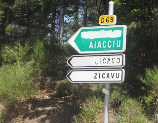
Corte still remains the centre of the nationalist movement, but since France has been investing heavily in roads and infrastructure, the benefits of separatism are not so clear to the population at large.  Still, somewhat provocatively, the French administration insists that, since Corsica is part of France, all road signs should be presented in both French and Corsican, with the French at the top.  This has led to the local sport of shooting road signs – similar to the Australian country traditional pastime – but not the whole sign, only the French words.  As shooting skills fall away with increased urbanisation the sport has transformed into spray painting the French signs as illustrated here:-


All very well and understandable to some extent, even after 200 years, but driving around with a French road map and trying to guess the names from the Corsican signs did prove challenging for our intrepid navigator.

If you know nothing about Corsica, and you want to do something more than get sunburned on the beaches in the south, Corte is the best place to start. The reason is the Musée Régional d'anthropologie.  This museum is mainly based in the work of a monk who was sent to Corsica to teach natural history to young men in the Seminary.  Father Louis Doazan took advantage of the trust afforded to a priest in this almost entirely catholic country to document the life, traditions, tools and culture of the Corsicans between 1953 and 1970.  His collection is the basis of the central exhibition of the museum which provides an insight into traditional life in Corsica.  Doazan then went on to work for five years with the National Museum of Popular Arts and Traditions in Paris where he chose to study pastoral farming in Corsica.

The museum has added a very well presented section on industry and economic development in the 20th Century as well as some descriptions of life and music in the cities. 

Corsica made much more sense to us after a few hours at the museum.

The pictures in the link provide some views of the small (under reconstruction) roads we travelled on across the mountains, the stonework in the traditional buildings and one of the many pigs who came out to greet us on the way between Porto Vecchio and Corte.

Corte and the road

Thursday, 14 July 2011

Corsica - a stroll in the mountains


Choosing a guide is important.  Sylvie is exactly what you want – fit, informed, passionate about Corsica and very generous with her time- but she has one fault when it comes to guiding through the mountains.  She is a marathon runner who has completed several of the sections of the GR20 – a walk (climb, struggle) across Corsica in 15 sections. 

Along with Jean, we headed up to the mountains, to a place called Col de Bavella on the road between Solenzara and Zonza (S is on the coast North of PV and Z is South West from there).  Amazing mountains, red granite, boulders, shear faces, crisp sharp edges and trees, trees, trees. We stopped in a French parking space (I am starting to recognise them now) and walked into a small, almost invisible gap in the vegetation onto a path which was mostly clear, narrow and on the edge of a sheer cliff, and the rest of the time was indistinct or non existent, on slippery sloped rocks, on the edge of a sheer cliff.  Once or twice it seemed to be straight down a sheer cliff.  At each new achievement along the way I felt I like I had conquered a major mountain, only to meet a family or a group of school children with minimal supervision strolling along ahead of me.

We found ourselves a spot on the rocks in the middle of a mountain stream and ate a full lunch, before heading back the way we came.

It was a great day with great scenery, but my knees and heart are both complaining.

The pictures from the day are here.


The Mountains

Tuesday, 12 July 2011

Corsican Music

Jean and Sylvie invited us to hear some Corsican music on our second night in Porto Vecchio. I’m thinking 7.30 for 8.00 pm and wondered why our beach visit with Sylvie did not end until around 7pm.  Then there was dinner, and some activity (I am never quite sure what is happening in France, so I just try to flow with it). We left home at 10.40pm.  Arrived in Porto Vecchio at around 10.50 pm which in itself was a surprise, because Dominique and I took around an hour to get from PV to Sylvie’s house the first time. PV was another surprise, because clothes shops were open and waiting for customers at 11pm, so I guess they have adopted the night time living which is typical of Spain. 

We arrived at a small pub under some very old arches and at 11 pm three guitarist / singers and one drummer (who also played the sax) arrived on stage and proceeded to deliver powerful, three part harmony in voice and on guitar for one hour continuously.  We bought the CD, I hope is sounds like the performance.

At one stage, after a particularly passionate rendition of something in Corsican, everyone clapped and cheered. Jean told us is was the national song.  We left at midnight, and the clothes shops were just closing. Some bars were starting to look like they may open.

Corsica -Bonifacio

Bonifacio is a town originally established on a cliff in 828 by, who else but, Bonifacio, Marquis of Tuscany who saw the spot on the way back from Africa to Tuscany.  I am not sure what was going through his mind at the time, but when I see a cliff almost inaccessible from the sea, I don’t immediately think, why don’t I go in, subdue the locals and build a town.  I guess that is why I am a tourist taking photos of a town named after him. It was not an immediate success, existing for the next 350 years on fishing and piracy until the Genoese took over and built the walls and the fortifications which you can see in this photo.
   
View over the fortifications to Bonifacio Harbour

Judging by the prices and the amount of fish for sale in the restaurants, it still clings to its traditions.
  
The Grain Seen from Bonifacio
The town changed hands a few times between the French and the Genoese, just like the rest of Corsica, but still retains an Italian flavour, if only for the food and the Italian tourists.

The cliffs are chalk, just like the white cliffs of Dover, but they are an anomaly in a country which is almost entirely granite and other volcanic rocks (more of that later).  The coast has some similarities to the Victorian coast along the great ocean road, with stranded rocks such as this one which is known as “The Grain” and was first separated from the mainland around 800 years ago.


Today Bonifacio is mainly a tourist town and a port for pleasure craft.  When we visited in the evening there was a very large pleasure boat in the harbour


the word around town was that it was owned by someone from St Petersburg.

One of the many beaches

Sylvie took us off the beaten path along a track down the coast which allowed us to gain an appreciation of the many inlets, passages and cliffs.  The water is extraordinary with every shade of blue. The small beaches like this one are generally almost empty, but today was the beginning of the two month tourist season.

As the water remains shallow for a considerable distance out from the beach it is warm.  The sun is hot, but does not seem to burn as does the sun in Australia (believe me, it is my expert area gained from many years of experience and painful observation).

We visited several of the beaches along the coast between Porto Vechio and Bonifacio, and the first impression on arrival at each was that the place was crowded with water craft, swimmers, power boats, ferries, surf-skis and any other available water sport.  However, when I tried to take a photo of the chaos, I found something like this:-


---- space for all and plenty of room between.

All the beaches have similar not too cold water, shallow calm seas and plenty of areas to swim, play or just lie around and get very burnt, which seems to be the objective of many of the French, Italian and German tourists. 


My overwhelming impression is of red skin.


Corsica


After our trip on the ferry from Toulon overnight we landed at Adjaccio about half way down the West coast of Corsica, and left almost immediately to head for Bonifacio and then on to Porto Veccio to stay with Dominique’s cousin Sylvie and her husband Jean, a real live Corsican. We stayed with Sylvie and Jean for a wonderful three days and were treated to a guided tour of all the beaches, features and secret places of the South West.


I had never thought of going to Corsica, and we really only decided to come after Sylvie’s son visited us in Sydney, but if you are in France it is worth the trip over. 

Monday, 11 July 2011

Saturday, 9 July 2011

Toulon

Our main reason for visiting Toulon was to meet the ferry to travel to Corsica. We also took the opportunity to visit Dominique’s school friend Elizabeth.  We have been here before, but that was in January 2010 and at that time we took a ride across the harbour to look at the French Navy, which has used Toulon as a base for around 500 years.

Toulon from the Ferry.  Plenty of boats
We had a spare day to look around and, without much conviction, chose to visit the Maritime Museum.  What a surprise. It had a wonderful set of models, pictures and artefacts relating to the development and life of the Port and Naval Base at Toulon, ably illustrated by an excellent audio guide in several languages (I chose English this time). I was surprised to find that the most interesting exhibit for me was the series of paintings from the 17th century illustrating life at the port. The description in the audio guide focused me onto details which I would not have otherwise noticed, even the one time when I was looking at the wrong picture.

The Bastia Ferry, ours was bigger with two extra decks


We left Toulon on the 9pm ferry to Ajaccio, Corsica.  The sister ferry which was headed to Bascia, Corsica at the same time left behind us.  

Some pictures from my new camera, showing the Bascia Ferry and the skyline of Toulon.

Apart from the smokers, Toulon is better in Summer.


Link to some more photos of Tulon

Some Technology Updates

You may have noticed a few things: no recent photos, gaps in the timing, and wondered why? Well all the best laid plans fall apart somewhere along the line. 

First, when I arrived at Paris CDG, I turned on my new toy, the NetComm MyZone credit card sized wireless modem, only to find that I had provided the wrong starting date for the sim card – one day later.  I patiently waited the day, but when I turned it all on again, no signal.  Skip the details, it took five days to make the automatic configuration configure.  Nothing to do with the undocumented reset button.

After mastering this simple technology, things looked set to flow smoothly.  About 40 minutes before the expected arrival of the TDF peloton, I decided to change the memory card in my camera. I did not want to miss any of the action. That is when the new memory card reported an error.  Oh well, just have to make do with the 22 available photos in the old memory card. Changed back to the old memory card. Error as well. The camera has not worked since. 

I bought a new Canon IXUS, so I hope to have some photographic evidence that I am not just sitting in Pymble making this up.

The Peloton Rides

We were joined in Noirmoutier by John McGarry, who was a regular member of our bike riding group between Meadowbank and Parramatta on Sunday mornings, while in Australia for summer. He caught up with us to see the start of the TDF and stayed with us in Noirmoutier.

The opportunity to reform part of the Meadowbank Peloton for an international sojourn was too good to miss, particularly in a place which describes itself as the île du vélo.  On the day we arrived we hired bicycles and rode to the Passage du Gois and back, a mere 32 km round trip, half of it into the wind.  On the Sunday, after John had gone, Dominique suggested we hire some bikes and ride the 8 km circuit described on the notice board near our hotel.  We got lost and rode around half the island – another 30km – but saw all the beaches and some pretty towns along the way.  Both of these rides was on dedicated bike pathways, well sign posted and connected to the main square in the centre of town.

This morning’s news in Le Mans is that the local Conseil Régional for the Sarthe area has announced that it will soon be possible to ride on dedicated bike paths from Le Mans to Mount Saint Michel and from Le Mans to Paris within a year. 

The horizons of the peloton may yet spread further afield.

Noirmoutier

Noirmoutier-en-l’ÎIe is the main town on the Île du Noirmoutier, not surprising really. The island which is located about 4.5 km off the Atlantic Coast of France is connected to the mainland the Passage de Gois, a cobbled causeway built at the point where the waters meet at high tide and part first as the tide goes down. No one seems to be saying when the Passage was constructed, but a local told me that it was established when the Dutch were running the island which places it at somewhere after 1657.

Sitting out on the edge of France, with a solid strategic position, it seems to be a favourite place to invade. The Vikings started the habit in the early 800s, arriving every year around salt harvest time to collect some of the valuable product.  The English tried and failed in 1342,1360 and 1396, the Spanish in 1524 and 1598 but the island held out against all of these before it fell to the Dutch in 1657. Noirmoutier was the site of the final act of the Vendee uprising against the French Republic in 1793.

It is this last event which still plays a strong role in the island’s self image. First some background. Following the revolution in 1789 and the Reign of Terror, the French Republican Government sent its armies to Vendee (the area to which Noirmoutier attaches) in 1793 to conscript 300,000 young men for the Republican Army.  The Vendee area was not so enthusiastic about the revolution – it supported the King and the Catholic Church – and so the locals decided that if they were to die fighting, they would do it for something they believed not something they opposed. From this was born an army which captured considerable weaponry from the Republicans and defeated the Republicans in several decisive battles over the next year or so. They were eventually defeated in Le Mans and the result was the execution of around 15,000 prisoners.  The Republicans did not stop there and sought to eliminate all opposition by wiping out towns, crops and buildings all the way from Le Mans to the coast.

The remnants of the Royalist army, including its leaders Le Tesselier and Fontiniere retreated across the Passage de Gois to Noirmoutier, presumably to regroup. However, the republicans managed to take the island and execute the leaders of the Royalist army. The story becomes a little unclear from here, but there are reports of people leaving the north of the island by boat to escape the reprisals, and people in Noirmoutier-en-île being massacred, leaving no royalists.


I am not sure they left no royalists, because today the Hotel de Ville (the town hall and the main representative of the republic in every town) does not display the French Coat of Arms in contrast to every other Hotel de Ville in France. The Hotel du General d’Elbée, where we stayed was named after the Royalist General, had its rooms named after the leaders of the Royalist Army, and it backed onto a street called the Passage de Martyrs. In fact the manager of the hotel told us that the Republican leaders watched the execution of General d’Elbée from the balcony window of our room.  In the local museum there is a full description of the glorious acts of the Royalists and the atrocities of the Republicans.   They still take their money, though, and build impressive roads and public buildings, and make most of their living from French tourists in the summer holidays. 

Tuesday, 5 July 2011

Tour de France


After family visits in Paris, Mamers and Vendee, we headed for the island of Noirmoutier for the start of the tour de France (TDF).


The tour was planned to start at the entrance to the island near the bridge and then to pass through the south area and across the Passage de Gois.  Like several other semi-attached islands in this area (think Mont Saint Michel as the most famous) it is possible to cross from the mainland on a land bridge for one and a half hours each side of the low tide on the otherwise submerged Passage de Gois.  Luckily, we arrived at the entrance to the island just in time to cross.  After finding our hotel and hiring some bikes, we rode the 16km out to the Passage de Gois (and back uphill into the wind), to review the options for Tour de France spectators.  This is what we saw.


Our view of the Passage de Gois
The next morning, keen to get the best position in order to catch the action we left the hotel at 7am to ride with the locals on the free bus to the Passage de Gois.  We arrived at the chosen spot and perched ourselves on the rocks right at the edge of the water.  This is how it looked about an hour after we arrived.


Stories of a previous TDF which raced across the Passage had us excited about the spectacle, and as the tide receded we could see why.


In 1999, half the peloton lost six minutes when one rider slipped on the wet road and there was action aplenty with bikes and riders stuck in the mud or piled on each other. You can see the result here:


We were just in front of the spot where the road narrowed.  Combine that with a rough stone surface, fresh mud and wet road, and anything could happen. 

The first thing that happened was that the caravan commenced.  The caravan is the name given to the vehicles which precede the TDF with sponsors logos, beautiful young men and women throwing things to the crowd, music blasting, and plenty of talk over the PA systems to excite the crowd.  Here is an example of one of the caravan members.


The next thing that happened was the caravan continued – for a total of three hours.  Given that it was travelling at around 20 km per hour, it could cover 50 to 60 km in the time it took to pass.  Then there was a lull, followed by team cars for about 5 minutes.  Another lull, then some excitement as we could see the helicopter which was tracking the peloton was over the approach road.  Then we saw the lead car and bikes.

For the next 35 seconds, we were treated to a peloton in tight formation travelling slowly and carefully onto the Passage de Gois.  Then they were gone.

Over three hours of advertising caravan, followed by 35 seconds of event.  Draw your own conclusions as to whether is was worth the early start, time and expense to get there, the wait in the sun sitting on a rock with French people climbing over us to try to get a better vantage point, the run back to the bus stop to catch it before it left at 1pm and the 30km ride the day before to find the best spot. Once is good, twice would be hard to justify.  If you want to see the TDF, watch it on TV.  If you want to feel the experience, by all means visit. Once.

UPDATE

In replacing a broken link to the 1999 video, I came across a video of the 2011 event.  You can see the motor homes, some of the "caravan" and from 11m 02 s into the video until 11m 28 s you can see the full peloton pass, very carefully and seven seconds faster than I thought!

What I can’t understand is the number of people who arrived in self-drive motor homes, camped for two days along the route, watched the TDF flash by in 35 seconds and then moved on to catch a vantage point to do the same the next day.  I must have missed something.

Our next encounter with the TDF was on the way back to Le Mans on Monday. Dominique navigating without a map on the departmental roads brought us to  St-Philbert-de-Grand-Lieu on the road to Cholet.  It was here we met the TDF for a second time. We arrived at 11am to be told the road we were trying to access was closed until 3pm for TDF to pass (another 35 seconds). After some gentle discussion with the gendarme and the swapping of some stories about Australia, Dominique won the day and the gendarme instructed us to follow him. Along the route and through the barrier and on our way.

Reunion Wrap Up


From Hellbourg we travelled south – out to the coast  to Saint André  and back up the next valley – to the town of Bourg Murat (near Le Tampon). This is the location of the La Maison du Volcan, a museum which opened in 1991 and is devoted to the study and presentation of volcanos around the world, but particularly to the two volcanoes which comprise Reunion, the Piton des Neiges and Piton de la Fournaise. 


The Piton des Neiges is the (allegedly) inactive volcano which forms most of the habitable part of Reunion. It rises 7000 m from the sea floor, and reaches a height of 3,000 m above sea level.  The last eruption of the Piton des Neiges was 12,000 years ago – not very long in geological terms, but long enough for people to assume it is ok to live on tip of it.  The Piton de la Fournaise is right next to the Piton des Neiges and seems to erupt every 7 to 10 years and as a result claims the title of the most active volcano in the world.  The museum, amongst many excellent displays and explanations of volcanos in general, had a 30 minute movie of the eruption of Piton des Neiges in March 2006.  Apparently the 2007 and 2010 eruptions were not worth mentioning.  The 2006 eruption completely destroyed a village and lava flowed across the main road in the SSE of the island. Don't remember hearing about it on Australian TV and News Media.

View from Nez de Beoffe
We tried to visit the volcano, but were defeated by roads and time. The drive to the Nez de Boeff took nearly an hour on Tuesday afternoon (about 15  km) around thousands of hairpin bends, narrow roads and sheer drops.  Our plan was to drive to Pas de Bellecombe (along the same road but 30 km further on) the next day and walk the three hours to the top of Piton des Neiges.  Given the difficulty of the drive, the need to come back on the same day and then head to the airport and the likelihood of a difficult walk, we decided not to try this time but to come back again better prepared, possible next January.

Instead of heading up to the volcano, we drove back to St Denis, took in some of the local markets and museums and then drove to the beach at St Giles (near Saint-Paul)  to eat and look out to sea while waiting for the plane to Paris.

Tuesday, 21 June 2011

Hell-Bourg


Hell-Bourg, one of the “Plus beau village de France”, in fact, the number 1 outside “Metropolitan” France, was established in 1830 and put itself on the map with the discovery of hot springs in the vicinity.  The town was named Hell-Bourg in honour of Governor de Hell, who promoted the hot springs (probably as a reaction to a difficult time at school with a name like Hell).  It is now famous as one of the Unesco classified Creole Villages which have distinctive architecture as illustrated in the photos below.


Apart from the buildings, Hell-Bourg is famous for being inside the cone of a (claimed) extinct volcano.  This has two effects.  Firstly, the road in clings to the side of a steep ridge high above a raging river, and secondly, the sport of choice is either drinking rum (the pressure of living on the edge) or running over mountain tracks.  Just once, somewhere in the world, I would like to labour over a difficult walk for a couple of hours and not have someone jog past me the other way after running all the way to the end and half way back.  It happened not once, but four times on the track to Belourve – a spot somewhere on the ridge above Hel-Bourg with an elevation of  1,507 m towering above the 900m high Hell-Bourg.  It seems that there is a race across the island which lasts 2 days, over the mountain tracks and the half of the population that does not drink rum is currently training for the race.  We heard this from a Swiss man, young and fit who walked the track that took us two hours in around half the time.  He had just finished the walk across Réunion in 10 days. So it must be some kind of a race.

However, it was not all confidence shattering for the intrepid walkers.  A least we did better than this guy.


The view from the walk was pretty impressive, and more so since the weather on the way up was fine and clear. We had the opportunity to look down on Piton d’Anchaing at a mere 1,352 m…..


……… and to be reminded of the only road out of town


and to remember how it looks when you come too near the edge!


We spent the afternoon at the herb garden of in the house of M. Folio and discovered that the camellias in our garden at home have a productive use.  If you rub the flower between your hands for a bit, it turns into a natural soap.  The town and surrounds are full of interesting plant life….


…. and some friendly locals.


Monday, 20 June 2011

Day 1/2 Sydney to Réunion : St Denis and then on to Hell-Bourg


There are two very good reasons to fly Air Austral.  The air fare is $1,750 return to Paris, and the plane is only half full.  Once on the plane, the food is very good and the service is attentive, relaxed and friendly.  In addition I have found that, with advancing age, 24 hours in the air is just too long, and the deteriorating Qantas service – including the latest blitz on bag weights – is only bearable when cashing in frequent flier points.  So a stop on Réunion Island in on the itinerary.

Réunion has spent most of its history as a French colony.  That status is very different from the glory of being a British Colony. French colonies are part of Metropolitan France and so have the advantage of using French currency, having representation in the French parliament and having all the French institutions (including French bread) transplanted in the community.  The British on the other hand tended to take from their colonies.  I did not understand the difference in 1976 when travelling in Africa, but I could see the results then, and they continue today.  Réunion has a modern airport, a modern functioning airline with new planes, a freeway all around the island, and what appears to be a safe, clean place to live.  It also has the most active volcano in the world and a landscape that you would expect from a volcanic island with a sufficient rainfall coming off the Indian Ocean to support a rainforest. 

As it is built on the sides of and in the craters of old volcanoes, the centre of the island is steep and rugged.  Since it has a high rainfall and steep slopes, every where you go you hear water running. If you stand still too long something will grow over you.

It also has some beautiful, steep winding roads with deep drains on the side and a sheer drop of about one metre into the drains. Combine this with driving on the right side of the road after a 12 hour flight the day before, and you have a pretty clear description of today. Just to add spice, include French trained drivers and the threat of rain and fog, 25⁰, 90% humidity and no air conditioning.  The scenery was impressive, but I only saw the edge of the road and the cars coming the other way or overtaking me on the hairpin bends.

One of the features of the vegetation is bamboo.  I am not sure it is native, but is sure feels like it is at home! It is everywhere and comes in all shapes and sizes.  In spite of the fact that it is strong, flexible and useful for all manner of things, I still thing of bamboo as the preferred  material for Brother Richard's cane.  I can't look at it with any positive thoughts!

Before we set off from St Denis, with the help of jet lag, we spend a few hours in the morning walking around the city centre.  Our first stop was the cathedral where we discovered that it was First Communion Day.  Everyone dressed up and happy, fine sunny morning and a lovely setting in the garden in front of the cathedral was all too much for Dominique to resist. She was there in the middle taking photos and talking to the kids.


We arrived at Hell-Bourg, a town of 600 inhabitants, in the middle of the island at around 1 pm on Sunday – French Fathers Day – and so joined in the festivities and tried the local Creole food. These Creoles make a fine chocolate mousse.  The main course was fish or pork or chicken mainly curried or spiced.  Coconut and beetroot feature heavily.  We spent the afternoon walking around town taking pictures of the  Creole houses for which the town was listed by UNESCO.  Tonight we will try some of the local rum and try to shake off the jet lag  before testing ourselves on one of the many (steep) walks around here tomorrow.

The Technology


Apart from the blog, other technology has changed since 1975.  My digital SLR Canon 350D seems dated after only 5 years, but still takes great photos.  Unfortunately, the 50 mm lens does not fit it!  Apart from the camera, however, I have been spectacularly unsuccessful in mastering technology on the road, with several huge bills from Telstra to prove it. So I have given up and decided to copy people who do it better than I have done.

The first step is staying connected. While there is Wi-Fi at every airport and rail station and also in many hotels, I never seem to be able to connect to it. I have noticed that the more expensive the hotel the more expensive the Wi-Fi – so that it is generally free in a hostel, and up to $10 per megabyte in a 4 or 5 star establishment.  In any event, I need some connectivity when out and about – and data roaming is out of the question.  So I stole an idea from “Around the World” and purchased a Netcom MyZone wi-fi modem – about the size of a credit card.  I have combined this modem with a sim card from iPhone Trip.  The MyZone card provides wi fi across 3G which can be shared across several devices using normal wireless connection, while the iPhone Trip sim provides unlimited 3G data downloads almost anywhere in the world.  Unfortunately, Isle de Réunion, did not show up on the list, so I chose my activation date as the start of the French leg of the journey.  As it turns out, politically and administratively, Réunion is part of France, so the card would work here as well.  Remember that for next time!

I have installed the Truphone app on my iPhone which will allow me to make calls over wi-fi for 2 c per minute, so that will reduce the cost of the global roaming.  I also downloaded “700 City Maps” app to provide mapping without continuous downloading ( makes no sense with unlimited data!) along with a map of Réunion to stop me from being lost.  Not such a great solution for a number of reasons. The first is that the iPhone is too small to be a useful map except in emergencies. Secondly, the iPhone GPS is very poor, with an accuracy of anywhere between 150m and 1 km.  When I tried it today it put me in a park next to the beach.  Trouble was, I was in the hotel three streets away! And finally, the map does not expand to a useful scale and show all the street names. Maybe it will in the big cities.

My computing needs are still served by a Dell Inspiron 700m, six years old, speakers not working (headphones ok) one usb plug not functional and the hard disc filling up too often.  However, it is robust and reliable, so it is having one more holiday.

Then there is the Kindle.  I bought the Kindle DX (larger format version) so that I could read pdf files at a reasonable magnification, and it has proved a great success for 90 page board papers. So I brought it along to try to reduce the weight in my hand luggage.  Last year we spent 4 weeks in France and Korea starting late January, and I had finished the three (heavy) books which I did not want to throw away within the first week.  I read them twice, but still had a few gaps.  So I have loaded up the Kindle with some reading relevant to the trip, and some board papers! We will see how that goes.

I was very excited a few years ago to come up with the idea of resealable plastic bags to carry my cables plugs and chargers, but the bags always lost interest in resealing before the end of the trip.  So now I have decided to steal Vanessa’s idea of a click seal lunch box. A bit of a tight squeeze but the converter plug, the camera cable to connect to the laptop for downloading photos, the iPhone charger, the kindle charger and the charger for the MyZone all fit in.  I have seen some ads for consolidated USB chargers, bud did not find a suitable one to take this time.  Bringing all the chargers into one device is on the top of my technology wish list.

On with the trip.

The Start


Thirty five years ago, in March 1976, I left Sydney and headed for South Africa, first stop Mauritius.  I kept in touch with my family, and occasionally with my friends, with an aerogram once every two weeks or so. I took slides on my Canon Ftb, with 50 mm, 1.4 lens (still the best lens I ever owned). We phoned home occasionally by queuing up at the Post Office and calling reverse charges.


Yesterday, I left for France, via Isle de Réunion, just a short hop across the water from Mauritius, and decided that this time I might try my hand at recording the trip on a blog.  I started this blog a few weeks ago just to see how to do it, so I thought I might use it!

The trip will last around 5 weeks, and will cover a few days in Isle de Réunion looking for volcanoes and bananas (not the $14 per kilo bananas with no taste), followed by some family visits in Paris and Mamers (where we will catch up with Vanessa), then down to Vendee to visit  Dominique’s cousin, Gerard.  From there we will cross to the Island of Noirmoutier to be there for the start of the Tour de France.  The race will leave the island along the famous "Passage du Gois" (the submersible road) to the mainland and away for a couple of weeks of pain  - provided they meet the tide.  We, on the other hand, will head down to the South of France, and over to Corsica, before heading back through Paris and home.